Despair Slope
Subtitle: Conquering the "Slope of Despair": A Hiker's Guide to Wugong Mountain's Most Infamous Trail
Introduction: The Allure of the Forbidding Path
Nestled within the expansive Wugong Mountain Scenic Area in Luxi County, Pingxiang City, Jiangxi Province, lies a trail segment that has earned a name as dramatic as its terrain: Juewang Po, or the "Slope of Despair." This is not a path for the casual stroller. Its reputation stems from a formidable combination of extreme incline, considerable length, and rugged, unrefined footing, presenting a physical challenge that can indeed feel overwhelming. However, for seasoned hikers and adventure seekers, it represents a quintessential rite of passage. The Slope of Despair is the crucial, non-negotiable connector for those undertaking the iconic multi-day traverse from Wugong Mountain's Golden Summit (Jin Ding) to the adjacent stunning massifs of Yangshi Mu or Mingyue Mountain. It is a journey where the intense struggle of the ascent is perpetually counterbalanced by some of the most surreal and breathtaking alpine scenery in the region, creating an unforgettable narrative of hardship and reward.
The Nature of the Challenge: Why "Despair"?
1. Extreme Gradient and Unforgiving Terrain The primary source of the slope's daunting moniker is its sheer physical geometry. The trail here is characterized by a sustained, punishing incline. At its most severe sections, the slope angle approaches a staggering 70 degrees. This is not a gently switchbacking tourist path. Progress here is elemental and demanding. Hikers will find themselves navigating a raw, unimproved surface of loose stones, gravel, and hard-packed earth. There are no manicured steps or supportive railings for much of this segment.
2. The Art of the Ascent: Hands and Feet Consequently, traversing the Slope of Despair is a full-body endeavor. The technique shifts from standard hiking to something closer to scrambling. Using both hands and feet is not just advisable; it is often necessary for maintaining balance and forward momentum. The climb is slow, methodical, and physically taxing. Each step requires careful placement, and the constant engagement of upper body muscles adds to the overall exertion. It is this sustained, hands-on battle against gravity that encapsulates the "despair" – a moment where the summit feels perpetually distant.
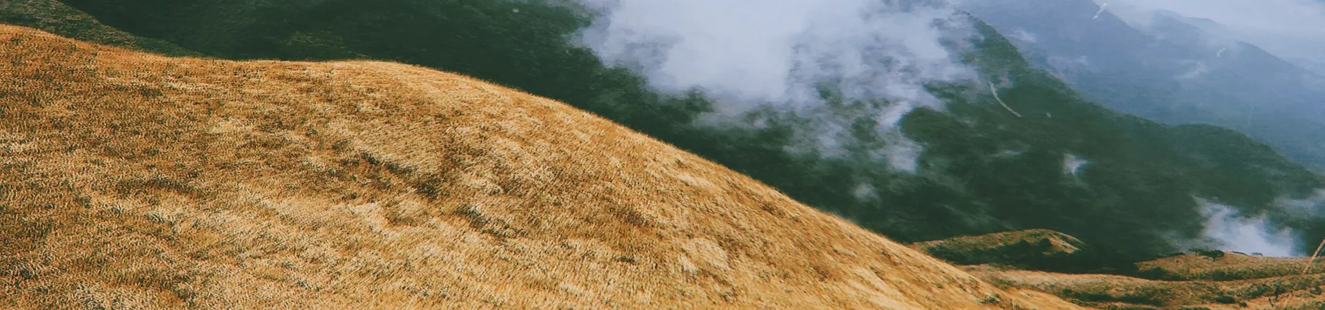
The Transcendent Reward: Landscapes of Ethereal Beauty
1. A Realm Above the Clouds Paradoxically, the very factors that create the challenge also forge the landscape's extraordinary beauty. Due to the high altitude of this section of the Wugong Mountain range, the area is frequently shrouded in mystical clouds and rolling sea of fog (云海, yunhai). As you labor upwards, you may find yourself piercing through layers of mist, emerging into clear sunlight with vistas of distant peaks floating like islands above a white, cottony ocean. This ever-shifting atmospheric drama creates a scene straight out of a classical Chinese painting, evoking a sense of being in a celestial paradise.
2. Unique Alpine Vistas Beyond the clouds, the panoramic views are consistently dramatic. The rugged, rolling contours of the Wugong Mountain massif unfold in every direction. The trail offers sweeping perspectives of deep green valleys, jagged ridgelines, and the vast expanse of the surrounding wilderness. The unique grassland ecosystem atop parts of Wugong Mountain, often compared to a "green meadow in the sky," can be appreciated from new angles here. The play of light and shadow across these landscapes, especially during sunrise or sunset, provides a profound visual reward that makes every arduous step worthwhile.
Practical Information for the Journey
1. Location & Access The Slope of Despair is situated deep within the Wugong Mountain circuit. It is critical to note that Wugong Mountain has multiple access points, with the two main official entrances being in Anfu, Ji'an City and Matian, Pingxiang City. The slope is part of the cross-mountain hiking route connecting the core areas.
2. Transportation Hubs and Routes * From Pingxiang: * Pingxiang South Station: Direct buses to Wugong Mountain (Jin Ding Cable Car ticket office) operate frequently from approximately 6:00 to 16:50, departing every 20 minutes. The journey takes about 1 hour and costs around CNY 18. * Pingxiang Railway Station: Upon arrival, you can take a dedicated express bus from the long-distance bus station near the train station. This bus route passes by attractions like West Sea Hot Spring and Fayun Jie before reaching the mountain area. It runs from about 5:40 to 17:00, departs every 20 minutes, and costs approximately CNY 22. * From Ji'an (Anfu side): * Ji'an Railway Station: A direct bus departs at 6:30 AM for Wenjia (near the mountain), arriving at the Wugong Mountain Hot Spring Villa around 10:00. It returns to Ji'an Station at 13:00. This service has one daily departure, priced around CNY 25. * Alternative Route: Take a bus from Ji'an to Anfu County (frequent departures, ~CNY 15, 30-min intervals), then transfer to a bus from Anfu to Hukeng Town, which passes by Taishan Township (get off here for mountain access). This leg also runs every 30 minutes and costs about CNY 10.
3. Ticketing and Opening Hours * Ticket: Access to the Slope of Despair is covered by the general Wugong Mountain Scenic Area entrance ticket. There is no separate fee for this specific trail. * Opening Hours: The scenic area is officially open from 08:00 to 17:00, daily throughout the year. However, hikers attempting the full traverse (Jin Ding to Yangshi Mu) often start very early and may be on the trail outside these strict hours; this requires prior planning and an understanding of the route.
4. Time Allocation and Preparation * Suggested Duration for the Slope: While the provided reference suggests "under 1 hour," this can be a significant underestimate for most. Traversing the entire Slope of Despair segment can easily take 1.5 to 3 hours or more, depending on fitness level, weather conditions, pack weight, and frequency of stops for photography and rest. * Essential Preparation: This hike demands serious preparation. Sturdy, ankle-supporting hiking boots with excellent grip are non-negotiable. Weather can change rapidly, so pack layers, rain gear, sun protection, and ample water and high-energy snacks. Trekking poles are highly recommended to aid balance and reduce knee strain. As mobile signal can be unreliable, a physical map, GPS device, or pre-downloaded offline trail map is crucial. It is always safest to hike with a partner or group on such challenging terrain.